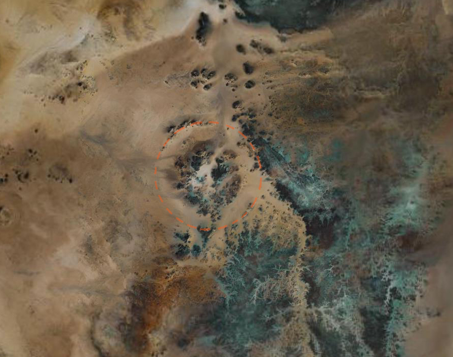
 The proposed crater is double-ringed with an outer rim surrounding an inner ring. In the LandSat image shown here, the dotted orange ring shows the 31km diameter line of the outer rim. The shape of the image is similar to that of many double-ringed craters on the moon, with which Dr. El-Baz is familiar from his time working on the Apollo program.
Professor El-Baz goes on to speculate that the crater could have been made by a meteorite that was approximately 1.2km wide and was quite probably the event responsible for the "Libyan Desert Glass" (LDG), an extremely pure form natural silica glass found in Western Egypt, in the Southern part of the Great Sand Sea. However, it was impact guru Gene Shoemaker who said that you can only talk about an impact crater after you've been to the actual site and investigated it first-hand. Your claim should not be based just on aerial or space images.
This particular site is not easy to get to. Firstly, it is in the deep Sahara desert where the nearest tarmac road is a thousand kilometres away. It requires an expedition equipped for desert travel for at least a week to get to this area and back again. Secondly, the proposed crater site straddles the Libya/Egypt border. Libya has never been a country into which it is easy to gain access. Since the war with Egypt in 1977, relationships between Egypt and Libya have been tense and special permission is required to visit the border area from the Egyptian side. So, the chances that anyone would visit the site in the near future to test the idea that this was the site of an impact crater were slim....
Having been down to the Gilf Kebir to look at rock engravings and cave paintings, we proceeded Northwards back to the area where Libyan Desert Glass is to be found. The site of the supposed crater was on our way (more or less) so our group made a little detour to have a look at the sit.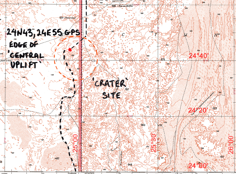 The sand in the area has a reddish hue and the ground is littered with rocks that look as if they have been burnt black in a fierce heat. On reflection, the red sand indicates a high iron content in the rock here and the stones may just have oxidised to a black oxide, such as happens to petrol cans, oil drums, old cars and other junk that gets left in the desert. Anyway, the impression was that at some stage in the past, this area had been a furnace which was truly a hell on earth, as it would have been if a meteorite had lanced from the sky and smashed into the plateau nearby, instantly pulverising and vaporising the rock. We threaded our way between hills with cinder black cones that rose like volcanos out of the desert floor.
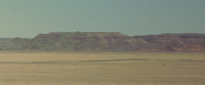 Finally, we stopped and Andras, our group leader, came over to announce that we were now inside the outer rim of the impact crater and that to the East, we were looking at the central uplift area. I took a photograph with my little Olympus Trip 35. The raised escarpment we were looking at appeared as a thin band across the 35mm slide photo, (as I knew it would), but I was able to blow up the section showing the escarpment. It is a little fuzzy, but it is plain to see the horizontal layers of sedimentary rock, which seem undisturbed except by the processes of natural erosion. Is this what we expect to see in the central uplift area of a complex impact crater?
We headed in a few kilometers towards the 'central uplift' and stopped for a closer look. The GPS gave a latitude and longitude of our stopping place, which is marked by a red dot on the map shown here.
Impact craters are formed when a meteorite, coming in at speeds of around 25km/second, impacts the bedrock. The immense energy from the impact fragments and melts the rock which then behaves much like a liquid. With simple craters, the lighter components are ejected from crater site and are distributed radially around it. Chunks of impact melt and breccia (sharp, angular rocks) settle back into the bottom of the crater. On Earth, simple craters can be up to about 4km in diameter. But if the impact energy is high enough, complex craters of larger diameters are created.
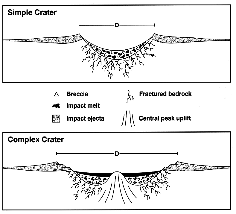 In complex craters, a central peak or peak ring is formed as the deep crater floor rebounds from the compressional shock of impact. Slumping of the rim further modifies and enlarges the final crater. Where the initial bedrock was crystalline, complex crater sites will also contain coherent sheets of impact melt on top of the shocked and fragmented rocks of the crater floor. On the geologically inactive lunar surface, this complex crater form will be preserved until subsequent impact events alter it. On Earth, weathering and erosion of the rocks quickly alter the way the crater looks. Despite the crater’s initial shape, crater rims and ejecta blankets are quickly eroded and concentric ring structures can be produced or enhanced as weaker rocks of the crater floor are removed. The more resistant rocks of the melt sheet may be left as plateaus overlooking the surrounding structure.
So, is this what we are looking at in the photo, a plateau with the original melt sheet on top with softer impact rubble beneath? I don't think so. In the photo, many bands and layers of sedimentary rock can be seen. This is not a hard cap of crystalline melt sheet on top of softer rock. I do not think that this is a crater site.
However, it seems that Dr. El-Baz knew Gene Shoemaker well and fully agrees with Shoemaker's sentiments about impact crater claims. So a team of "experts" is going out to the site in the fall of 2006 to have a closer look. I look forward to their conclusions!